Keywords
- Internet of Things / IoT (Internet of Things)
- Smart city, Smart building, Smart grids
- Indoors géolocalization
- Geostatistical Dashboards and Cartographic Dataviz
Description
Arx iT puts Geographic Information Systems and cartography at the service of the Internet of Things (GeoIoT).
Whatever your IoT project (smart city, smart building, health, safety, security, agriculture, industry…), the use of digital maps or plans as well as associated cartographic functions are an essential asset to operate and manage your connected objects.
GIS and IoT interactions are multiple:
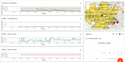
- Administering and managing background plans and sensors deployed in infrastructures and/or spaces that are sometimes complex, vast, difficult to access…(what are they measuring? where are they? are they working? what are their battery levels?…).
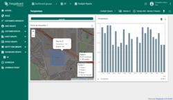
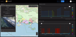
- Analyze and exploit more efficiently, through interactive 3D maps and plans associated with powerful cartographic functions and spatial analysis (geostatistical dashboards), the measurements taken by the sensors.
- Study, optimize, pilot and control the deployment of the sensor fleet in the field (distribution, localization, referencing, coverage zones, inter-distances…).…).
New service offer: GĂ©oloT
Services
The scope of our services covers :
- Studies / Consulting
- Where / How to implement and optimize an IoT device (sensors, complementary gateways…)
- What architecture to put in place
- How to use the data collected
Achievements
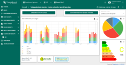
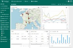
- Back Office Web-based business analysis and operations (Dataviz)
- Web-based administration and management back office
- Mobile applications (iPhone, Android…)
- Indoor / outdoor geolocation
Data processing
- Creation of 2D/3D “building” scale background plans
- Creation of territory-wide plan funds
The fields of activity that we address in our geoloT offer are multiple:
- Energy, street lighting
- Safety, security
- Agriculture, viticulture
- Industry 4.0, maintenance
- Health, culture, sport
References
- Web and mobile infomobility (State of Geneva)
Creation of a website offering real-time road traffic conditions, parking conditions and instant images of traffic on the motorway.
- Monitoring of the state of the cash dispensers (Transports Publics Genevois)
Development of a web application for real-time monitoring of the status of TPG cash dispensers.
- Web development for parking management (Parkéon)
Realization & Integration of ArcGIS Online route search services in an application for managing and optimizing maintenance campaigns for public parking terminals.
- Indoors géolocalization
Indoors géolocalization solution co-developed with ESRI France for the Paris Airports with the technology ArcGIS Indoors
arx iT on social networks