Keywords
- BIM, Building Information Modeling
- BIM-GIS or GIS-BIM convergence
- BIM Management: strategy and organization of BIM processes
- Scan 3D / Scan to BIM
- IFC
- Revit, ArcGIS, ArcGIS Urban, Infraworks, Navisworks
- Clash detection and reporting
- Digital and collaborative mock-up
- Augmented Reality, Virtual Reality
- BIM Manager, Coordinator, Modeler
- SwissBIM / ScanWays partnership
Description
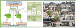
rx iT is active in the field of BIM (Building Information Modeling) and especially in the convergence or link between GIS – BIM. BIM-GIS interactions are multiple:
- Convergence of GIS – BIM tools and data through evolving exchange formats such as IFCs.
- Creation of a GIS-derived data base – cadastral data, telecommunications networks, transport networks, environmental data, land type, subsoil cadastre, existing constructions – for the location of BIM projects such as urban projects or transport infrastructures
- Reintegration of relevant data from BIM to GIS
Prestations
arx iT offers services around BIM – GIS convergence including:
- Consulting and analysis for the implementation of convergent BIM and GIS processes within public and private organizations.
- Development and implementation of software gateways between the 2 worlds, based on market leading tools such as FME, ArcGIS, ArcGIS Urban, ArcGIS Indoors, Revit, Navisworks, Infraworks…
- 3D capture and GIS-BIM modeling of territory and buildings
On the BIM theme, arx iT collaborates with historical partners such as SwissBIM and Scanways.
References
- RoadMap BIM Etat : consulting and expertise mission for the realization of the RoadMap of the BIM of the Canton of Geneva for the period 2018 – 2021, with determination of the migration steps and assistance to the BIM-SIG convergence, in multidisciplinary collaboration with three other partners that are SwissBIM, the Ecole Polytechnique FĂ©dĂ©rale de Lausanne (EPFL – ENAC) and the company Gambi-M.
- EPA Marne: Audit and proposal for the evolution of the management system of the reconciliation plans within the framework of the DAO / SIG / BIM flow.
- Oil Client (Confidential): Designing a script to convert AutoCAD facility plans to the GIS data model.
- Dijon MĂ©tropole : AMO for the definition and acquisition of a 3D base in CityGML LOD2
arx iT on social networks